


The novel Cannery Row revolves around the people living on that street during the Great Depression: Lee Chong, the local grocer; Doc, a marine biologist, based on Steinbeck's friend Ed Ricketts; and Mack, the leader of a group of bums.

Cannery Row itself is now a tourist attraction, with hotels and restaurants located in former cannery buildings, and a few historic attractions. Some privately owned fishing companies still exist, housed on piers located a short distance from the historic district. In recent years, Cannery Row has become increasingly popular among sport fishermen due to extensive public fishing facilities, are scuba-diving spots.


My next stop, and my overnight rest , was in the little town of Carmel, or Carmel-by-the-sea as it wishes to be known by its 3,000 inhabitants. As far as I can see it is best known for having one of them, Clint Eastwood, as its Mayor in the late 1980's.


My friend travelling this same route, ten days ahead of me sent her report:
"Carmel was very charming - quite an upmarket kind of place: boutiques, antique shops, wineries, art galleries, nice little restaurants. No chains here! And interesting architecture - a bit like being in rural Spain. My guide book describes it as being for "the newly wed and the nearly dead", and I think that's about right. A nice place to potter about hand in hand looking at things. I'm not very into shopping, and I'm not that interested in buildings, the town didn't hold much for me. But the beaches were nice: white sand, lots of pelicans, lots of nice views, although not very safe for swimming. The beach is west-facing, so a good (and very popular) place to watch the sun set". I concur with all that
The next day was Big Sur.
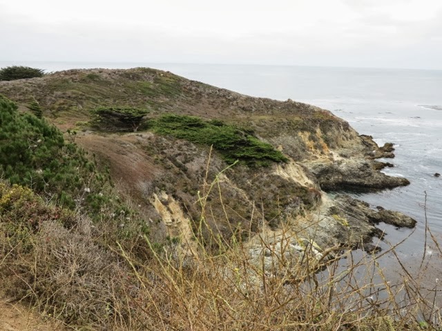


Although Big Sur has no precise boundaries, it is largely taken to include the 90 miles (140 km) of coastline from the Carmel River running south into San Luis Obispo county, and extend about 20 miles inland. Another practical definition of the region is the segment of Route 1 between Carmel and San Simeon.

Although some Big Sur residents catered to adventurous travelers in the early twentieth century, the modern tourist economy began when Highway 1 opened the region to automobiles, and only took off after World War II-era gasoline rationing ended in the mid-1940s. Most of the 3 million tourists who visit Big Sur each year never leave Highway 1, because the adjacent Santa Lucia mountain range is one of the largest roadless areas near a coast in the Us. The highway winds along the western flank of the mountains mostly within sight of the Pacific Ocean, varying from near sea level up to a thousand-foot sheer drop to the water. Because gazing at the views while driving is inadvisable, the highway features many vista points allowing motorists to stop and admire the landscape. The section of Highway 1 running through Big Sur is considered one of the most scenic driving routes in the United States.
Blasted out of the cliff face, the road is a configuration of zigzags, switchbacks, ascents and drops: the implacable Santa Lucia mountains of the Ventana Wilderness thousands of feet above, and the raging Pacific Ocean hundreds of feet below. It is probably the most scenic drive in North America.

Bixby Bridge, constructed in 1932, has appeared in many car ads and films.


Big Sur is 90 miles, only one lane in each direction, but it isn't really difficult driving. In fact the car-off-the-road incident I saw being attended to was on a straight stretch of road, with plenty of shoulder and no apparent distractions. I'm not sure, either, that I class this "the most scenic route in the world". It is impressive - as is the very fact of its construction - but there are equally majestic views In New Zealand, and in Switzerland.
After the drive concluded, and the road levelled out on the plain a few miles north of San Simeon, I came across this crowd scene, which can only mean one thing: wildlife.


And finally my long day ended at the Sea Breeze Inn, where I enjoyed this sunset.

No comments:
Post a Comment